
What Was The Great Wagon Road?

The Forgotten Colonial Interstate: History of the Great Wagon Road
Imagine packing up everything you own into a wooden wagon and heading into the unknown for months, guided only by rumor, rough directions, and the worn tracks of those who came before you.
No maps you could trust.
No paved roads.
No guarantee you’d make it.
Just a dirt path stretching 800 miles from Pennsylvania into the Carolina backcountry and beyond.
This was the Great Wagon Road. And for thousands of families in the 1700s, colonial America’s most heavily traveled “interstate” was the road to a new life and the pathway that forever changed the landscape of the American South.

Before the Settlers: Hooves, Moccasins, and Ancient Paths
Before a single wagon wheel ever rolled down this road, the path had already been worn smooth by thousands of years of travel.
It started, quite literally, with the animals. Buffalo carved the very first trails as they migrated in search of natural waterways, grasslands, and salt licks. One of the most famous stops along the route was a place called “Big Lick,” a natural salt lick near present-day Roanoke, Virginia, where herds gathered for generations.
Native American tribes, particularly the Iroquois, recognized a good road when they saw one. They adopted these well-worn animal paths as their own, using them as crucial routes for hunting, trading, communication, and warfare. The route through the Shenandoah Valley was known as the Great Warriors’ Trail, or simply the “Indian Road,” and it served as the western boundary of British settlement for decades. In those early years, it was little more than a narrow footpath, but it would grow into something much bigger.

The Floodgates Open: Philadelphia and the Push South
By the early 1700s, the port of Philadelphia was one of the busiest points of entry in the New World. A flow of settlers had begun by the 1720s, a decade of high immigration of Germans and Scots-Irish into Pennsylvania. These families were fleeing devastating wars, poverty, and religious persecution in Europe, enduring brutal ocean voyages of up to three months, just to reach the colonies. But upon arriving, many found that the good land in Pennsylvania was quickly disappearing.
The mostly Protestant German Palatines, often called the Pennsylvania Dutch, tended to find rich farmland and work it zealously to become stable and prosperous. The Scotch-Irish, mostly Protestant Presbyterians, tended to be restless, fiercely independent, and carried a centuries-old animosity toward the British Crown. Both groups, for their own reasons, began looking south.
The pivotal turning point came in 1744 with the Treaty of Lancaster. The 1744 Treaty of Lancaster settled Iroquois Nation claims in the Shenandoah Valley, dramatically opening the corridor to European settlement. Though traffic had been building for years, it now exploded. German and Scots-Irish families had already been traveling the road as early as 1732, when Jost Hite and roughly sixteen other families made the journey south to claim 140,000 acres in the Shenandoah Valley. After Lancaster, the trickle of settlers on this path became a flood.

One important caveat worth knowing: despite its name, the southern portion of the Great Wagon Road was not fully passable by wagons until later in the colonial period. A 1753 account noted that “the good road ended at Augusta” (current-day Staunton, Virginia), though travelers did keep pushing south.
Life on the Road: 800 Miles to a New Life
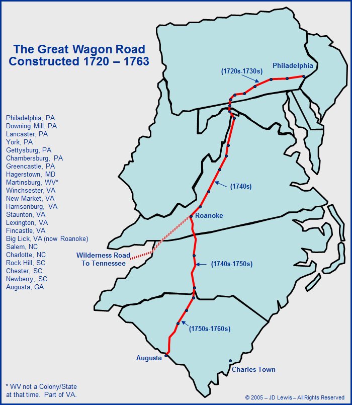
The Great Wagon Road began in Philadelphia, crossed westward through Gettysburg, turned south to Hagerstown, Maryland, and entered the Shenandoah Valley near present-day Martinsburg, West Virginia. It continued south through the 200-mile length of the Shenandoah Valley to Roanoke. From there, it pushed into the Carolina backcountry, passed through the Piedmont, and ultimately reached its southern terminus at Augusta, Georgia, on the Savannah River, a span of more than 800 miles.
But what was travel like on this road? Especially in the earliest days, it was an extraordinary feat of endurance. At first, the road was so narrow and rough that only travelers on horseback could use it, and the farther south they went, the more impassable it became. As settlers made their way along the trail, they cut trees, found suitable river crossings, and worked around obstacles until wagons could follow.
Much like the Hollywood-images of covered-wagon migration, people loaded Conestoga wagons, which were the most popular freight wagons used along the road. These wagons were made in Conestoga Township in Pennsylvania’s Lancaster Valley, with curved bottoms to keep jostled cargo pitched toward the center, but passengers didn’t ride in these; people walked or rode horseback alongside them. The sheer volume of traffic over the decades cut such deep ruts into the ground that remnants of the road still survive in places today.
A typical family might cover 15 to 20 miles on a good day, facing mud, dust, sudden floods, and the constant need to clear fallen timber from the path. Almost nobody traveled alone. Pioneers moved in large groups, arriving in the Carolina backcountry ready to settle into new communities together.
And it wasn’t just settlers heading south. The lines of southbound covered wagons were matched by wagons full of agricultural produce heading north to urban markets, interspersed with enormous herds of cattle and hogs, and as settlements spread, this became a full-fledged commercial artery, not just a migration route.

Transforming the Carolinas
As thousands of immigrants poured down the road, the Carolinas were transformed almost beyond recognition in just a few decades. North Carolina’s population more than quadrupled from around 52,000 in 1740 to roughly 270,000 by 1780, driven by heavy immigration from Virginia, Maryland, and Pennsylvania, as well as directly from Europe. By 1776, North Carolina was the fourth most populous colony in America, behind only Virginia, Pennsylvania, and Massachusetts.
The road didn’t just bring people; it brought an entirely new cultural geography. While the eastern coastal areas were dominated by English settlers and wealthy plantation owners, the western Piedmont and mountain regions were settled by fiercely independent German and Scotch-Irish smallholder farmers. Partly because of language differences, the two groups tended to keep to themselves, forming distinct cultural enclaves across the backcountry, focused around their respective churches.

By 1780, the southern backcountry had an estimated population of around 380,000, including Pennsylvania migrants as well as English, French Huguenot, German, and Highland Scots settlers who had moved inland from the coastal regions.
The Moravians: A Road Within the Road
One of the most fascinating chapters of the Great Wagon Road story belongs to the Moravians, a German-speaking religious community whose settlement in North Carolina became one of the most well-organized and historically significant ventures of the colonial era.
In 1752, surveyors accompanying Moravian Bishop August Gottlieb Spangenberg located a tract of 98,985 acres on the three forks of Muddy Creek, east of the Yadkin River, in what is today Forsyth County. The land was purchased from John Carteret, the Earl of Granville, who was one of the few Lords Proprietors who had held onto his North Carolina holdings. Upon viewing the hills, valleys, and waterways of the tract, Spangenberg was reminded of a beautiful ancestral estate of their patron, Count Zinzendorf, in Austria near the Danube. He named the new settlement Wachovia, a Latinized form of the German “Wachau” to honor the family that had sheltered the Moravians during centuries of persecution in Europe.

The first settlers arrived at the Wachovia Settlement in November 1753, including twelve single Brethren who had traveled from Pennsylvania. They founded Bethabara, intended as a transitional settlement until a permanent central town could be built.
Bethania followed in 1759, and the central congregation town of Salem was formally established in 1766. Today, the legacy of those settlers is everywhere: Old Salem Museums and Gardens preserves the heart of that original community, and the cities of Winston-Salem and the surrounding region owe their very existence to that wagonload of determined Brethren who followed the road south from Pennsylvania.
The route passed near Bethania, one of the early Moravian towns, and it is there that the state of North Carolina commemorates the Great Wagon Road with a highway historical marker today.

The Revolutionary Road
The Great Wagon Road wasn’t just a highway for settlers; it became a lifeline for revolution.
General Cornwallis himself recognized the vital strategic importance of the road during the Revolutionary War. Patriot and militia forces used it to move supplies up and down the backcountry to support western Continental troops. A number of significant battles and skirmishes occurred near the route during both the French and Indian War and the Revolution, and the corridor was also traveled by frontiersmen such as Daniel Boone and David Crockett.
The Scotch-Irish settlers who had come down this very road made up a substantial portion of the fighting force that would resist British authority. Their fierce independence now made them among the most formidable opponents the British faced in the southern backcountry.
A Road Hiding in Plain Sight
After the Revolution, the Great Wagon Road continued to serve as a crucial commercial artery well into the nineteenth century. Then the railroads came, and the old road began to fade, mostly absorbed into new routes, buried under development, or swallowed by the forests.
Much of the original route in Maryland and Virginia survives today as State Highway 11. In North Carolina, there is no single state or federal road that follows it, but parts of the old path can still be found in heavily wooded tracts, and local roads often trace brief stretches of the original route. In the twentieth century, some paved roads were laid directly over stretches of the road, and when you drive through Winston-Salem, Salisbury, or Charlotte, you’re moving along a corridor that tens of thousands of immigrants walked, rode, and hauled their lives down over the course of a century. The road is still there. The vehicles are just different now.
Citations
- The Great Wagon Road: From Philadelphia to the South. Rouse, Parke, Jr., 1973
- The Road That Made America: A Modern Pilgrim’s Journey on the Great Wagon Road. Dodson, James, 2022.
- The Scotch-Irish: A Social History. Leyburn, James Graham, 1962.
- Records of the Moravians in North Carolina, Volume 1: 1752-1771. Fries, Adelaide L.,
- NCpedia — “Great Wagon Road” — https://www.ncpedia.org/great-wagon-road
- NCpedia — “Wachovia” — https://www.ncpedia.org/wachovia
- NC Department of Natural and Cultural Resources — “Great Wagon Road Highway Marker (J-69)” — https://www.dncr.nc.gov/blog/2024/01/08/great-wagon-road-j-69
- Encyclopedia of Greater Philadelphia — “Great Wagon Road” — https://philadelphiaencyclopedia.org/essays/great-wagon-road/
- FamilySearch Wiki — “Great Valley Road” — https://www.familysearch.org/en/wiki/Great_Valley_Road (especially useful for genealogical research connecting ancestors to the road)
Do You Enjoy These Stories?
Help Support This Project So I Can Bring You More!
v


